Old Growth Trail
Most of the Old Growth in the OSU forests is relatively hidden. OSU doesn’t advertise it and there aren’t signs or trails providing direct access. The one exception is their “Old Growth Trail”, located about a 5-minute hike from the Lewisburg Saddle (off of Sulphur Springs Road, just north of Corvallis). The 1/2-mile long trail traverses a grove of truly amazing trees (with a dozen or more measuring 6-8′ in diameter). If you haven’t experienced this trail, you are in for a real treat! To find the trail, use this link to OSU’s McDonald Forest visitor guide and map (note: the Old Growth Trail is shown in blue near the Lewisburg Saddle in the center of the map):
OSU McDonald Forest Visitor Guide and Map: https://cf.forestry.oregonstate.edu/sites/default/files/_ResearchForestLAYOUT30May18.pdf
McDonald & Dunn Forest Maps
You can purchase large-format maps of OSU’s McDonald and Dunn Research Forests at local retailers or access them on-line using the links below. Note that the “mature forests” (Old Growth) are shown with a slightly darker shade of grey/green on the maps.
McDonald Forest Map: https://cf.forestry.oregonstate.edu/sites/default/files/McDonaldForestMap%20Reduced%20Size.jpg
Dunn Forest Map: https://cf.forestry.oregonstate.edu/sites/default/files/DunnForestMap%20Reduced%20Size.jpg
McDonald – Dunn GIS Map
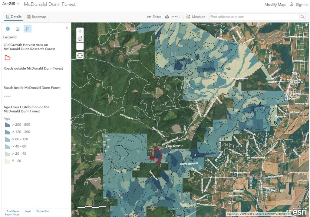
For a GREAT interactive (GIS) map of OSU’s McDonald – Dunn Forests (developed by Debbie Johnson of Applegate Forestry), click on the link below. The screenshot below shows what you will see at the ArcGIS link. Note the age class distribution (with older sections of forest shown with darker shading). You can change the basemap layers (e.g. to show topographical lines) and zoom in to look at individual sections of Old Growth. The original section of mature forest near Sulphur Springs and Baker Creek has been outlined in red (of this ~67 acres, nearly half has been harvested in the past year – though the image shows mostly intact forest). A HUGE thanks to Debbie for putting this amazing map together!
ArcGIS Map of McDonald-Dunn Forest: https://arcg.is/14mz0G

Sulphur Springs Old Growth
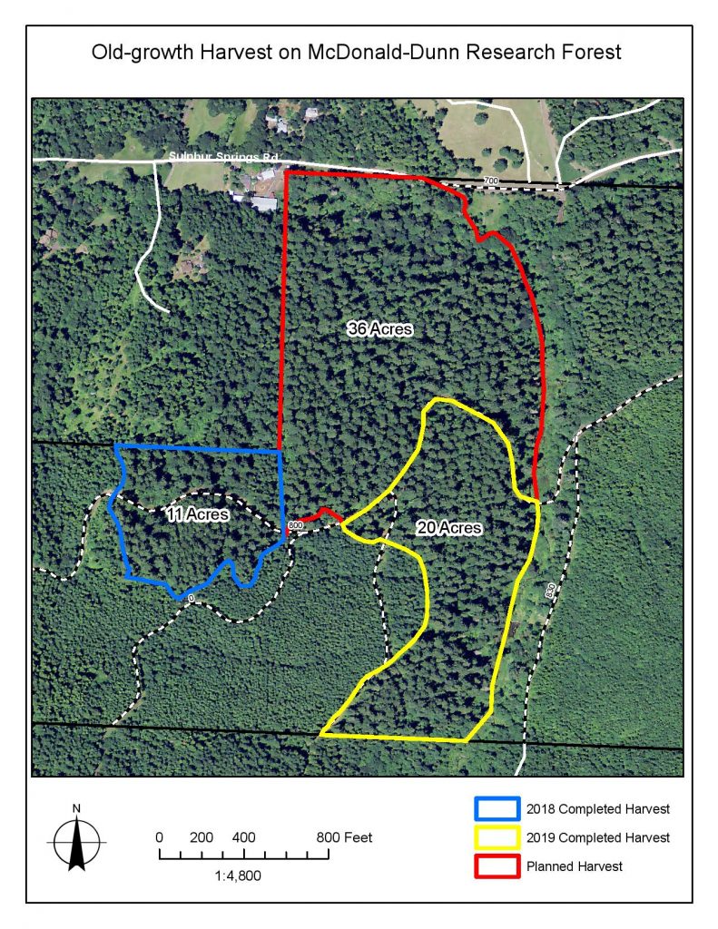
The map below shows the sections of contiguous, mature forest near Sulphur Springs and Baker Creek (just NW of Corvallis, in the Soap Creek valley). Note: the sections with both the blue and yellow lines have been cut (OSU’s recent “No Vacancy” harvest is in the section outlined in yellow). The future of the 36-acre “Sulphur Springs stand” (shown in red) remains uncertain. While the Dean has said they have no immediate plans to harvest these trees, it remains part of OSU’s “future harvest program”. You can find pictures of the Sulphur Springs stand in our photo gallery. You can use the ArcGIS link above to zoom in on the Sulphur Springs Old Growth and create/print your own map.
Update: On October 21st, 2019, Dean Davis formally changed the status of the 36-acre Sulphur Springs stand to “mature forest reserve” (Old Growth), thus protecting it from future harvests. This was a direct result of our group’s advocacy – thanks for making this possible! You can find the Dean’s letter in our “Latest News” section.

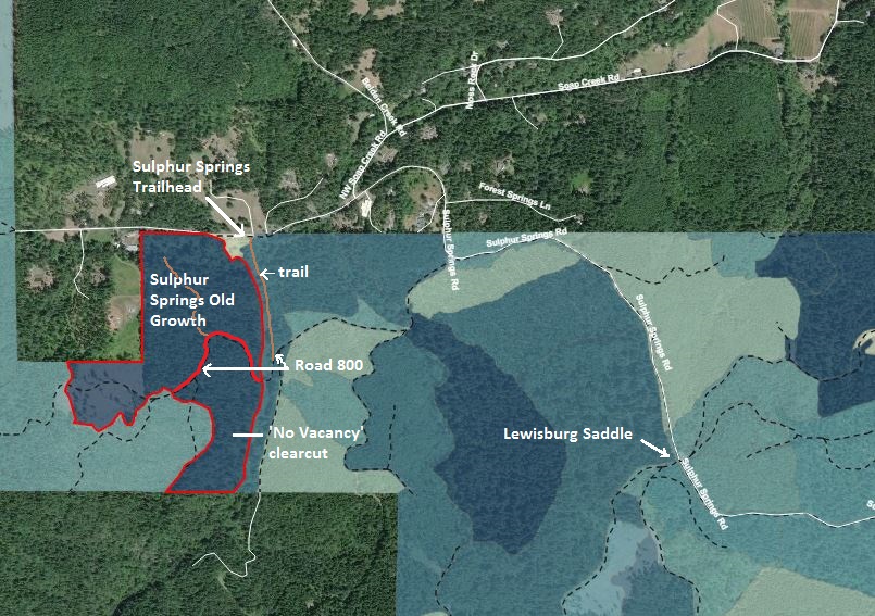
If you’re interested in visiting the ‘No Vacancy’ clearcut and/or the adjacent Sulphur Springs Old Growth, the overview map below shows the general location. You can park at the Sulphur Springs Trailhead and hike to OSU Rd. 800 via the pedestrian bridge and a beautiful (0.3 mile) trail. Once you reach Rd. 800, follow it to the concrete bridge over Baker Creek (approx. 1/8 mile) and up the hill along the edge of the cut. The road into the Old Growth is on your right, approx. 1/4 mile uphill. Note: the road into the Sulphur Springs Old Growth ends at Soap Creek (approx. 1/4 mile down the hill). There is no trail or bridge crossing the creek, so you’ll need to hike back the way you came. The views are just as nice on the way back uphill.

Please help to protect the remaining unprotected old-growth trees and stands by signing our petition! (click on the link at the top of this page)
